Flint Hills Trail State Park Field Guide

About the Flint Hills Trail
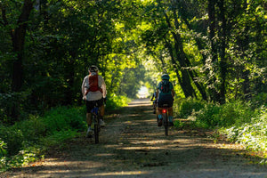
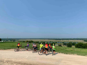
The Flint Hills Trail State Park features incredible views of the Kansas Flint Hills; one of the last remaining tall-grass prairie ecosystems in the world. The trail follows an old railroad corridor developed in 1886 for the Council Grove, Osage City & Ottawa Railway. The trail was previously known as the Flint Hills Nature Trail but it became a Kansas State Park in 2018 and is now known as the Flint Hills Trail State Park.
The trail extends 94 miles and visits the towns of Osawatomie, Rantoul, Ottawa, Vassar, Osage City, Admire, Bushong, Council Grove. The trail extends an additional 20 miles from Council Grove to Herrington. However, this part of the trail is unfinished and not currently ridable. Therefore we have not included this part of the trail in this guide. This section will be added as soon as it's in rideable condition
The trail follows the Marais Cygnes River as well as some of the original Santa Fe Trail Route.
Interactive Maps:
The map above is hosted on Ride With GPS. It contains markers for all of the points of interest along the trail. This includes lodging, trail heads, cities and towns, coffee shops, breweries, convenience stores, and other trail friendly businesses. You can download the map to your GPS device or phone. You can also print the map along with this guide to take with you on the trail.
Section Maps:
One of the best ways to experience the Flint Hills Trail State Park is by riding in sections over multiple days. We've developed three different section routes that can help you find the trail heads, points of interest, water and bathroom facilities, lodging, and other amenities in each segment. The segments can be ridden in either direction and in any order.
Eastern Segment: Osawatomie to Ottawa
Central Segment: Ottawa to Osage City
Western Segment: Osage City to Council Grove
Trail Conditions:
The Flint Hills Trail State Park is mostly well maintained rail-trail with hard-packed crushed stone surface. In the early days of the trail mixed surface conditions were found across the trail. However, in recent years the trail has been re-surfaced and is very rideable. As with any trail the weather conditions play a role in surface conditions. You’ll find that the trail surface is very forgiving and can usually be ridden during or shortly after normal rainfall. The trail may become muddy or soft in places after extended rainfall or during snow melt. Please refrain from riding the trail if your tires leave visable marks on the trail surface.
Much of the trail is tree covered and can become blocked by branches or obstructed until the trail is cleared by volunteers. If you come across branches or debres on the trail please do your part and clear the trail for other riders.
A few small sections of the trail can get washed out or may still need some work. As with any trail you may encounter ballast, gravel, ruts, holes, stickers, or wet and muddy patches. You may also encounter temporary closures or markers indicating that the trail is being worked on.
You should always stay alert and pay attention to changing trail conditions.
Reporting a Problem on the Trail
To report a problem on the trail call the State Park Office at: 785-448-2627
Wildlife on the Trail
Wildlife on the trail includes whitetail deer, bobwhite quail, wild turkeys, prairie chickens, and bobcats. Also, a wide variety of migratory birds, waterfowl, and butterflies can be spotted throughout the year.
Where to Stay
Camping on the trail:
Overnight camping can be found at several locations on the trial. We’ve indicated the camping spots on or trail map. The primary camping spots are as follows:
A small number of camping spots are available at John Brown Park in Osawatomie. There is a small fee for camping and you must pay the fee prior to setting up camp in the park. Fees can be paid at City Hall or the Police Station during normal business hours. You may want to call ahead and pay for camping ahead of your visit.
Lake Georgia-Sue is an 85-acre oasis of relaxation and fun located on the Flint Hills Trail between Ottawa and the town of Pomona. The lake spans 8 acres, offering activities such as fishing, swimming, small craft boating, kayaking, and windsurfing. It's an ideal spot for daytime rest-stops or overnight tent camping. Its proximity to Ottawa and the town of Pomona provides easy access to food and other amenities. The team at Lake Georgia-Sue continues to add amenities and the lake is an excellent spot for group campouts or events. You can reserve spots on Hip-Camp and contact them directly to schdule an event.
Pomona Lake State Park is located just a half mile north of the trail on K-368. The park has plenty of camping spots and facilities for cyclists and hikers. Reservations are not required but a tent camping fee applies. Fees can be paid at the front entrance or at the pay station near the entrance. The park contains multiple shower houses and water supply stations.
Base Camp Flint Hills in Allen
Base Camp Flint Hills offers excellent tent camping just feet from the trial. A water, a fire ring, and a portable potty are available for most of the year. The site also includes camper hookups. Reservations are encouraged. You can find all of the information on their website.
Council Grove Lake is just west of Council Grove on K-177 or Lake Road. The lake has seven different campsites each having tent camping. Camping fees apply.
Other camping spots:
Several of the towns along trail also offer camping in parks or grassy areas around county or city buildings. For example, The Franklin County visitor’s center in Ottawa allows tent camping in the lawn behind their building. This location is 1.5 miles from the trial and there are not facilities.
Lodging:
Hotel, AirBnB, Bed and Breakfast options exist primarily in Osawatomie, Ottawa, Osage City, and Council Grove. New lodging options continue to be available as the popularity of the trail increases.
Trailheads:
Osawatomie: Mile Zero Trail Head
Mile Zero Trailhead in Osawatomie has ample room for parking and bathroom facilities. Overnight parking is allowed.
Ottawa: Legacy Square Trail Head
Legacy Square is a parking, recreation, and event facility in Ottawa at the intersection of the Flint Hills Trail and the Prairie Spirit Trail State Parks. Overnight parking is allowed.
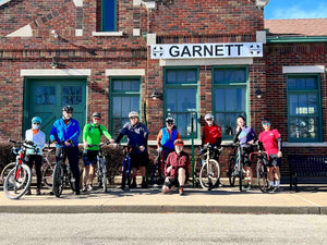
Osage City: Sante Fe Depot Museum
Parking is available behind the museum. The new trail is easily accessible from here. Overnight parking is allowed.
Council Grove:
Parking is available at the lot behind the 100 block on Main Street. Here is a link to the coordinates. Overnight parking is allowed.
Points of Interest:
There are many points of interest along the trail. You'll find many of them on the interactive Flint Hills Trail Map above.
Flint Hills Trail State Park Field Guide
The Flint Hills Trail State Park is a the longest rail-trail in Kansas and an incredible natural resource for the region. We want to be your one-stop resource for trail information and knowledge. Our Field Guide contains all of the information you need to make the most of your visit including trail heads, parking, camping, points of interest and more.
Prairie Spirit Trail State Park Field Guide
The Prairie Spirit Trail State Park is unique and equally as beautiful and interesting as the Flint Hills Trail. We can provide information and support to help you enjoy your visit.
Recommended Gravel Routes
Franklin County has some of the finest gravel roads you'll find anywhere in Kansas. We've developed a full list of gravel routes for you to enjoy.

